East Texas has seen its fair share of severe weather over the past month or so and it appears as if we could see another round of such weather again this afternoon.
Spring time in East Texas can be rough weather wise at times and it appears as if we could be in for a round of severe weather Wednesday afternoon into Wednesday evening and then clearing out Thursday morning.
It's that time of the year when our chances of strong to severe thunderstorms increase because of the changing of the seasons! This St. Patrick's Day is no different because there is a chance of scattered strong thunderstorms throughout the day for East Texas.
Flooding concerns are on the top of just about everyone's mind in East Texas the past couple of days. The threat of flash flooding still exists through at least Friday evening. With all the rain we've received the past few days, several cities have had to issue some sort of evacuation orders or disaster declarations and such. The City Of Tyler is the last city to issue such notice.
A pretty strong low pressure system and cold front will be moving through East Texas early Tuesday that has the potential of producing a lot of rain that could lead to some flash flooding. Rainfall totals, according to Mark Scirto at KLTV 7, could average anywhere between 2 and 3.5 inches with some areas receiving more.
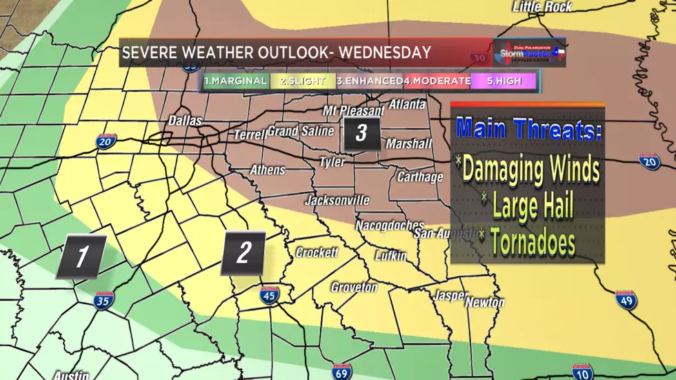
It is fall after all! Rain is to be expected this time of the year and more rain is in the forecast for East Texas and this time around it could be paired up with some severe weather, too.
It just keeps coming.
Yesterday in East Texas, we set rainfall records with upwards of four inches of rain falling in the Tyler-Longview area. And there's no sign of it slowing down anytime soon. Despite a brief respite this morning, another round of storms should be hitting the area by this afternoon and continuing well into the work week...
It's too soon to know for sure, but a new tropical storm could become a hurricane in the next few days and have an impact on Texas in the next week or so.