High Winds, Flash Flooding, Hail and Tornadoes Are Possible Monday Night

Another cold front and weather disturbance is on the way. East Texans will once again want to be weather aware Monday night into Tuesday morning thanks to another round of potential severe weather.
This weather event could produce winds in excess of 60 miles per hour along with hail up to one inch, flash flooding, along with the possibility of a quick spin-up tornado all in the cover of darkness
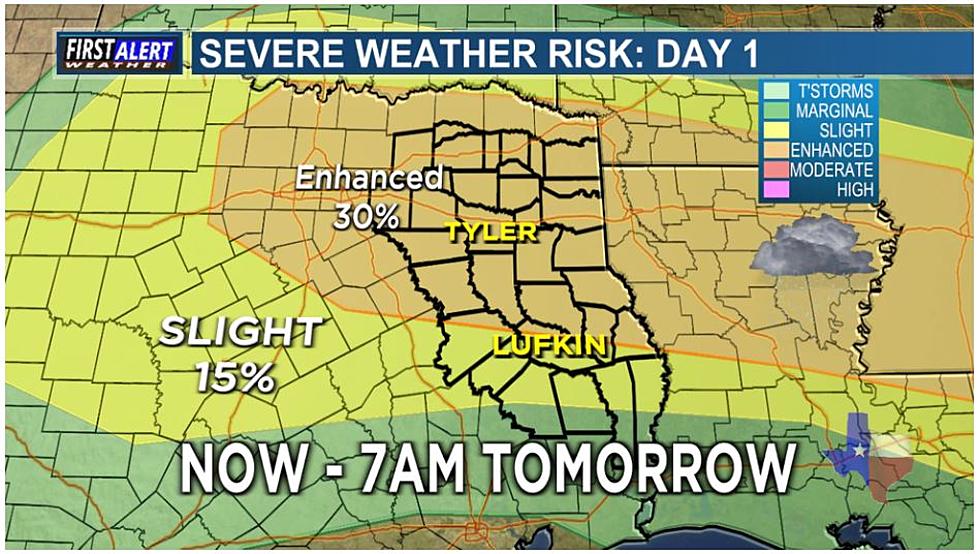
The Storm Prediction Center (SPC) has the majority of East Texas placed under an 'enhanced risk' of severe thunderstorm development late this evening. That means there is a 30% chance of a severe thunderstorm developing within this area as the line of storms moves in. This is a level three event, out of five, from the SPC.
Storms are expected to start impacting East Texas sometime after 8 p.m., beginning in our western counties and then moving eastward throughout the night and finally exiting the area around 2 a.m. Tuesday morning. KTLV 7 Meteorologist Katie Vossler says our biggest concern would be the individual storms that develop ahead of the line of strong storms, those individual storms could be the ones that could spin up a tornado.
Once the line forms, Katie says, it will mainly turn into a damaging wind event with winds in excess of 60 miles per hour being possible. Flash flooding is a potential too. As these storms move through they could be dropping as much as an inch or two of rain.
If you are out driving during these storms, or any others, and encounter a flooded roadway or water flowing over the road, turn around and don't drown. Water is very deceiving and can wash away your vehicle very easily. In addition, if you can't see the roadway below the water, you don't know if the road has been washed out by the stormwater.
KEEP READING: What to do after a tornado strikes
KEEP READING: Get answers to 51 of the most frequently asked weather questions...
LOOK: The most expensive weather and climate disasters in recent decades
Gallery Credit: KATELYN LEBOFF
More From 101.5 KNUE


