Severe Weather A Possibility For Portions Of East Texas
Another cold front and storm system could bring a round of severe weather back in to East Texas tonight and early Thursday morning.
Several parts of the U.S. have experienced severe weather over the last few days resulting in some pretty strong thunderstorms that have produced flash flooding and deadly tornadoes stretching from West Texas up through Ohio and in to New Jersey.
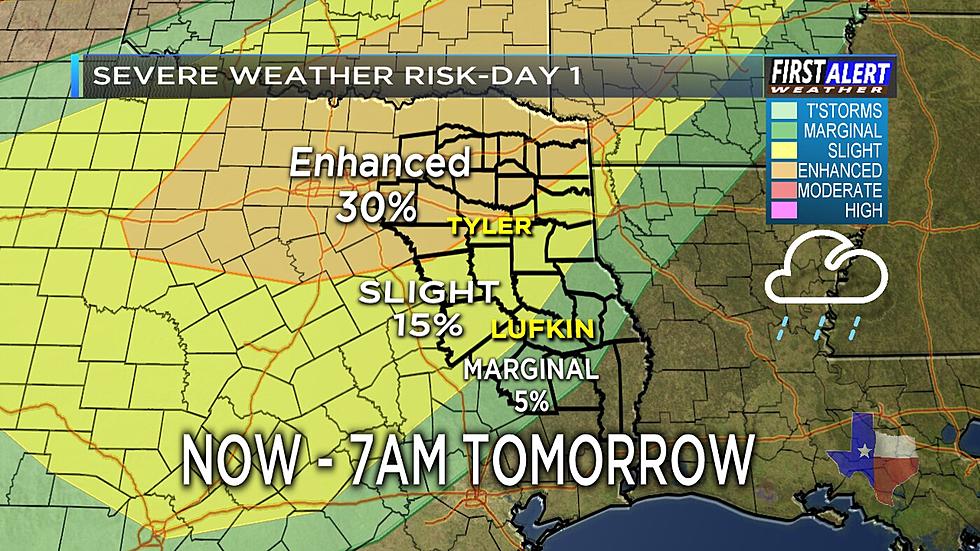
As a cold front moves in from the west, the northern and central portions of East Texas could experience strong to severe thunderstorms that will have the potential of producing high winds, large hail, flash flooding (along the I-30 corridor) and the possibility of a tornado. The risk of this kind of weather will begin to enter the area around 5 this evening and will continue throughout the evening. KLTV 7 Chief Meteorologist Mark Scirto has declared this evening as a First Alert Weather Day.

The Storm Prediction Center has a good portion of East Texas under the 'Enhanced Risk' of severe thunderstorm development while the western and southern portions of East Texas under a 'Slight Risk'. The National Weather Service will be posting a flash flood watch for the following counties that will go into effect at 7 p.m. this evening:
- Camp
- Cass
- Franklin
- Morris
- Titus
- Upshur
- Wood
- Delta
- Hopkins
- Hunt
- Kaufman
- Rains
- Van Zandt
In the event of a severe weather outbreak, we will keep you updated with reports from the First Alert Weather Center at KLTV 7.

More From 101.5 KNUE